GoMarie Logo

SRV Marie Tharp – A Collaborator for Mapping Greenland and conducting Research with the Climate Science Community

An Open – Inclusive – Co-Productive Quest to Map the Seabed and Coastal Processes across Sectors and Borders

Over 75% of the World’s Oceans are uncharted. Charting the world’s oceans is critical to understanding and adapting climate change. How can we tackle global warming—a multi-earth system phenomena—if we do not know what the foundation of Earth’s planet is like? It’s like trying to manage a balanced heating and cooling system in your house without knowing how much space you are working with or where exactly the floor is.

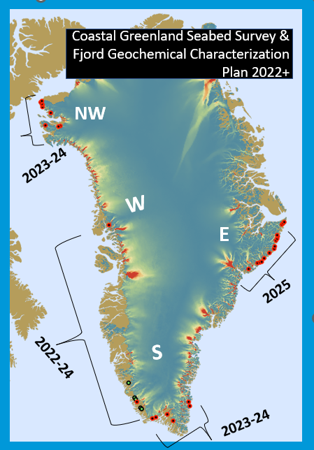
We won’t go all the way up there just to discover the unknown depths of the seabed. Wherever we go our observations on the physical-biogeochemical baseline will help to characterize the status of the marine ecosystem impacted by increases in glacial meltwater.

To advance the understanding of the Greenland Ice Sheet and its impacts on sea level rise we endeavor to disrupt the colonial approach to polar science exploration and we express our intent for a diverse talented team.

We must continue to map the accessible complex polar and sub-polar regions to further our understanding of climate change through the Ocean Decade. Ocean Research Project will GO in support of UN Sustainable Development Goals such as observed efforts including Seabed 2030 and the Greenland Research Strategy.

2023-2025 Greenland Gaps in Coastal Fjord Mapping Campaigns

Red circles are areas to map. Green circles are locations we have started or completed our mapping activities in 2022.

The Ocean Research Project (ORP) 2023 Expedition – GO-MARIE- (Glacier-Oceans Mapping & Research Interdisciplinary Effort) continues after a successful maiden voyage of the organization’s flagship, the R/V Marie Tharp, a 22m overall Bruce Roberts steel schooner. The ship’s name honors an under-recognized female scientist for developing the first detailed maps of the ocean seafloor. In 2022, the SRV Marie Tharp surveyed a dozen uncharted fjords in southwest Greenland. Some of these fjords were of great significance to confirm their fjord/ice geometry, current velocity of sediment runoff and the presence of warm water influencing deglaciation. Over 100 hydrographic profiles of ocean properties were collected in the fjords and nearly 400 km2 were surveyed. Data has been submitted to the global seabed map of the Arctic (IBCAO) and will be available at the NOAA NCEI NDBC archive.

The multi-objective international science mission to extend above the Arctic Circle starting in 2023. We are transitioning from a bow  pole mount to hull mount which will allow the team to better occupy high science priority glacial fjords towards hydrographic data collection.

Collaboration with major mapping partners including early recruits in mapping through the University of Charleston BEAMS program and mapping tech sponsorships like Hypack and RBR Map support our diverse global seabed mapping team while our activity is approved through diplomatic clearance from the Greenland & Canadian Government and Danish Embassy.

An Open Science plan and cross-evaluation with the Greenland Research Strategy is underway to improve the linkages with the primary regional communities for mapping project objectives in 2023-2025. Regional community engagement plans and co-production with Greenland researchers is being pursued through ISAFFIK and Arctic Hub and at Greenland Science Week.

There will be a base crew of seven including rotating ocean science experts joining legs of the 2023 voyage.

Now is the time to draw in resources, talent, and local knowledge to extend mapping and exploration contributions across the glacial impacted coastal oceans. High latitude communities and fishery economies are influenced by coastal glacier-ocean interactions. Gaps in coastal ocean water properties, composition and seabed depths lead to inaccuracies in estimates for glacier melt runoff volume and sea level rise rates. The success of the 2022 mission positions ORP to extend the survey activity further into the United Nation’s “Ocean Decade” as part of the Seabed2030 mission, an international collaborator to Greenland’s ocean research strategy and an ally in the Future of Greenland Ice Sheet Science (FOGSS) community.

How You Can Help Ocean Discovery

  • We need funds to operate our vessel to collect the critical observations needed for polar climate exploration. Please consider donating the costs of mapping the gaps of an uncharted glacial fjord.
  •  The observations are priceless but we need help running our low cost low environmental impact program. To have a talented diverse crew and local collaboration please considering sponsoring a the costs to support a woman scientist or sailor onboard or community participants in Greenland.
  • What are you comfortable with donating to ensure we map the uncharted coastline to altogether improve predictions from Greenland Ice Sheet melt?
  • For more information please contact the project principle investigator Nicole Trenholm, trenholm.orp@gmail.com

GOAL | 3 KEY SCIENCE OBJECTIVES:

  1. Of  the under-investigated glacial fjords determine the presence of warm ocean currents that melt ocean-terminating glaciers by observing physical ocean water column properties and by mapping the seabed of uncharted glacial fjords.
  2. Use underway optical and acoustic observations of the sea surface to evaluate how well satellites can interpret coastal water quality changes from glacial melt.
  3. Analyze the magnitude and geochemical character of the coastal glacial fjords from the sea surface to seabed towards identifying how glacier retreat influences the availability of nutrients for coastal biomass generation and how carbon burial processes change due to deglaciation. 

Data Sharing:

Questions, please contact Nicole at trenholm.orp@gmail.com

Models:

IBCAO-GEBCO data submission. January 2023, January 2024

BedMachine submission complete in September 2024 for pending version update.

Archives:

NOAA NCEI DCDB submission pending data population in archive database.

Join us for the Ocean Decade! Become a sponsor to help map the impossible. Email oceanresearchproject@gmail.com

MARITIME SPONSORS

SCIENCE PARTNERS / TECHNOLOGY SPONSORS